Intro

I'm an agronomic engineer with an MSc in Geo-information Science and Earth Observation for Natural Resource Management,
bringing over 9 years of expertise in geospatial solutions for sustainable resource management and humanitarian action.
My work spans land cover change detection, forest and crop monitoring, Index agri-insurance, and ecosystem services modeling.
I have also led innovations in food security mapping and the assessment of vulnerable populations.
I have collaborated with International NGOs, research institutions, and government agencies on projects at local to global scales,
driving innovation in natural resource, agricultural management and the humanitarian sector.
My passion lies in leveraging remote sensing, GIS, and spatial data analytics
for impactful decision-making and for a better world for all.
Work
Food security for humanitarian action
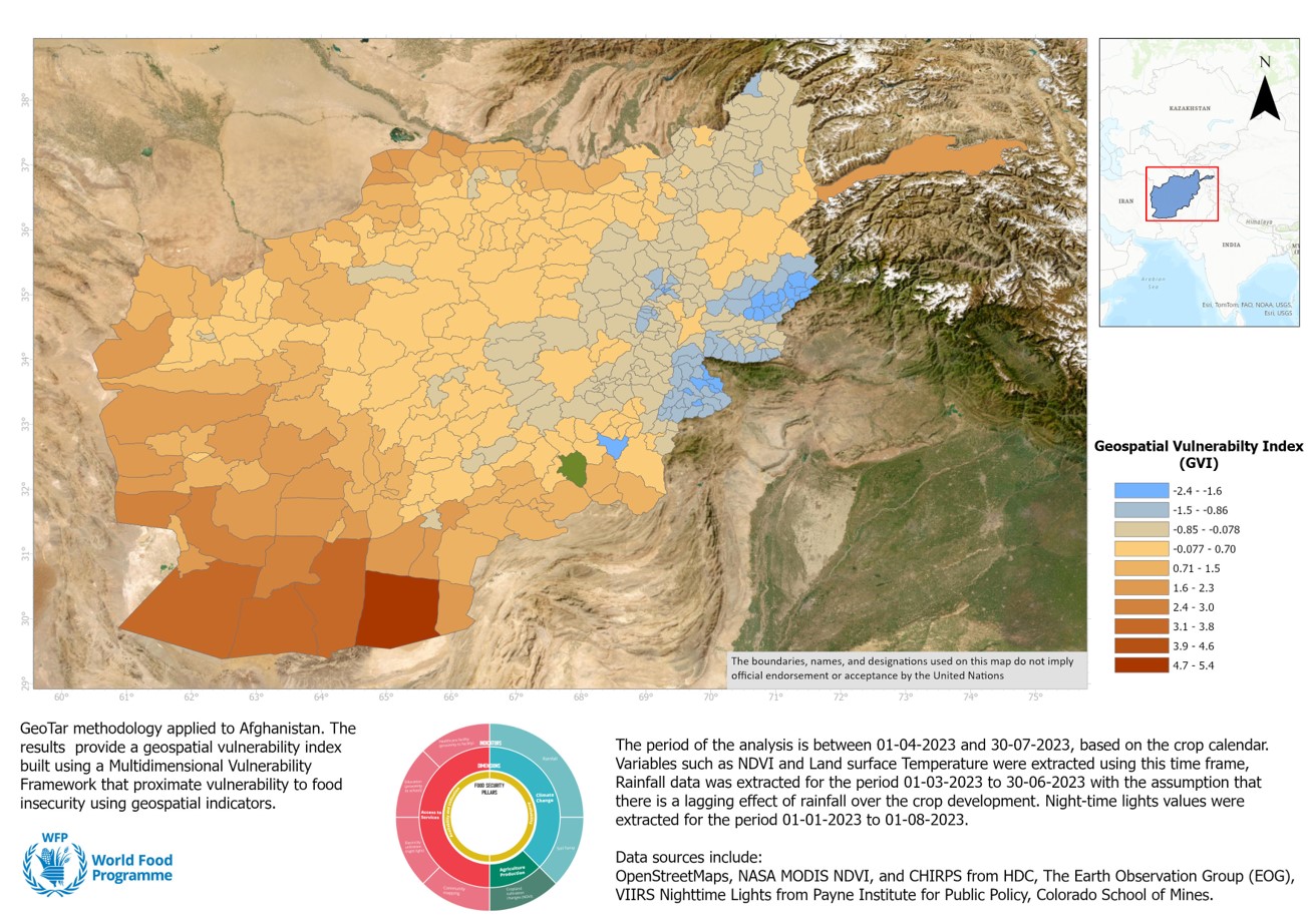
Worked with the United Nations World Food Programme on GeoTar,
an innovative project aimed to map community vulnerabilities using
open automated data pipelines, geospatial data, python, AWS, and AI.
This work supported evidence-based decision making in humanitarian interventions in
Afghanistan, Lebanon, Somalia, Sudan, etc.
Crop monitoring
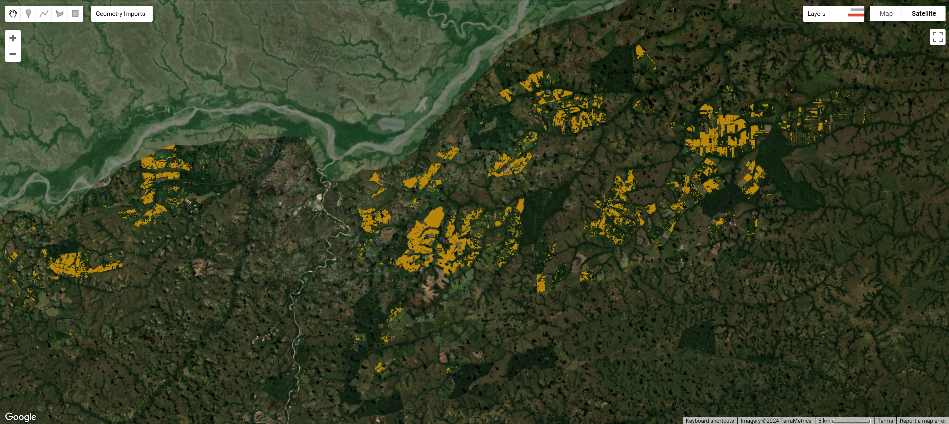
Contributed to the development of a national crop monitoring system using remote sensing imagery
for National Agriculture Planning Unit of Colombia (UPRA), leveraging AI, pattern recognition and Google Cloud Platform to support agricultural
planning and decision making at scale.
Forest monitoring
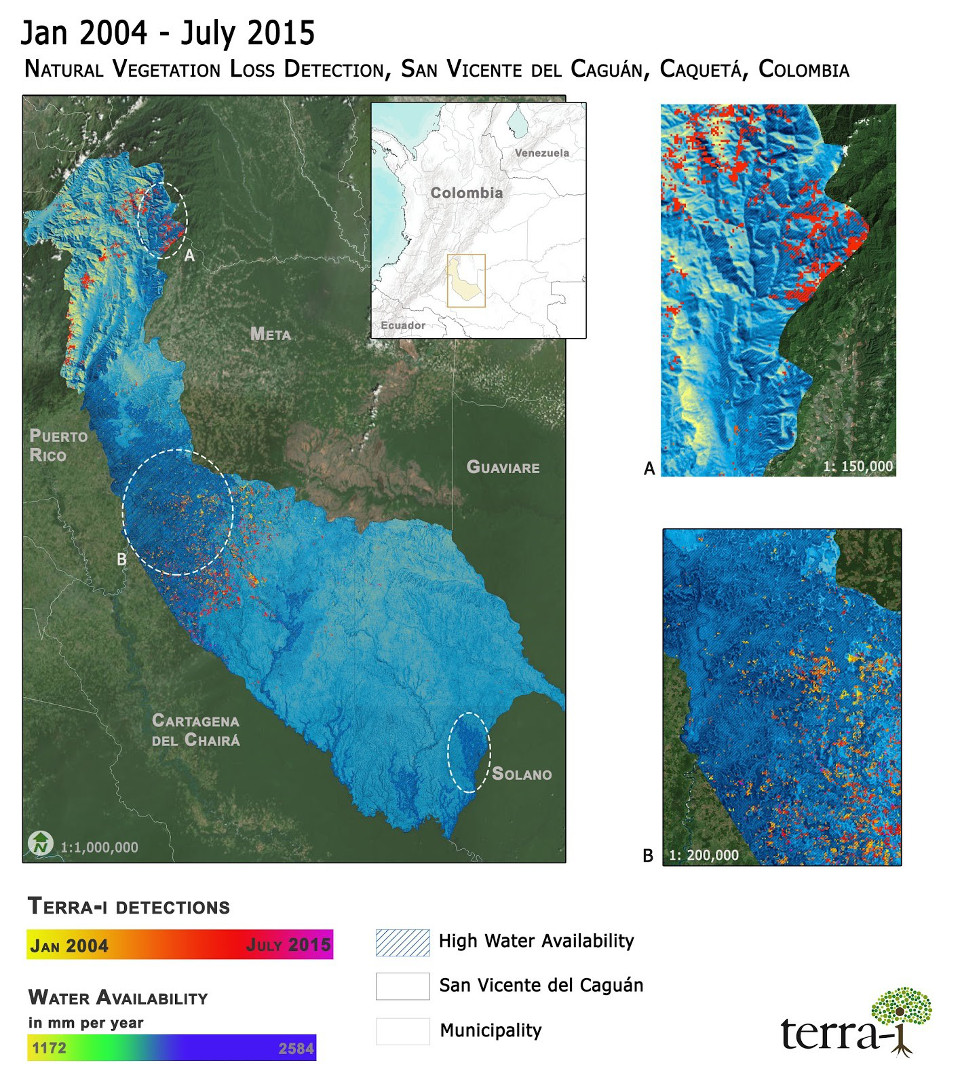
Participated in the Terra-i project at
the International Center for Tropical Acriculture (CIAT),
a pan-tropical forest monitoring initiative using big data to track land cover changes in near real time.
This work advanced near real-time forest loss detection and conservation efforts.
Agtech index insurance
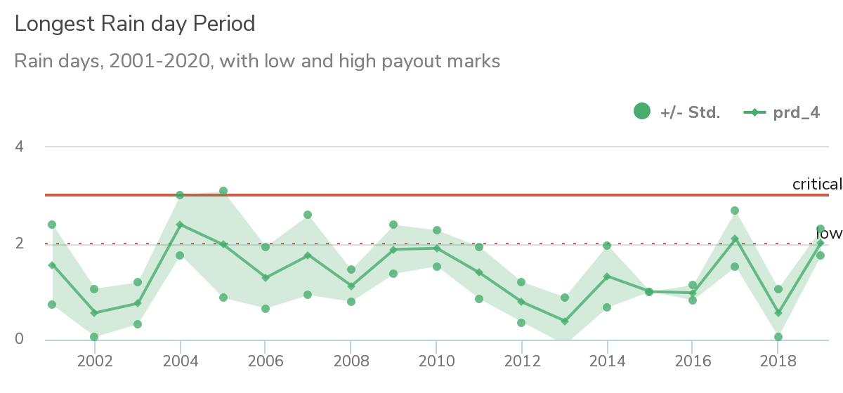
Collaborated with World Cover PBC, a USA-based startup backed by Y Combinator,
to advance innovative solutions for smallholder farmers across Africa.
The partnership focused on leveraging cutting-edge technology and data-driven approaches
to enhance agricultural resilience and financial inclusion.
By integrating satellite remote sensing, machine learning, and localized agronomic data,
we supported the development of scalable index insurance products tailored to the needs
of underserved farming communities. This collaboration exemplified the power of
tech-enabled development to address climate risks, improve rural livelihoods, a
nd drive sustainable growth in emerging markets.
Wetland mapping
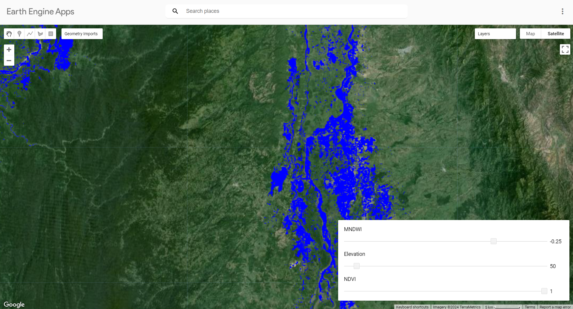
Collaborated with the Agencia Nacional de Tierras in Colombia to improve the technical delineation of land rights,
particularly in wetland zones. Used Google Earth Engine and cloud-based tools to process and analyze
high-resolution spatial and temporal data for policy development.
Web GIS and geospatial dashboards
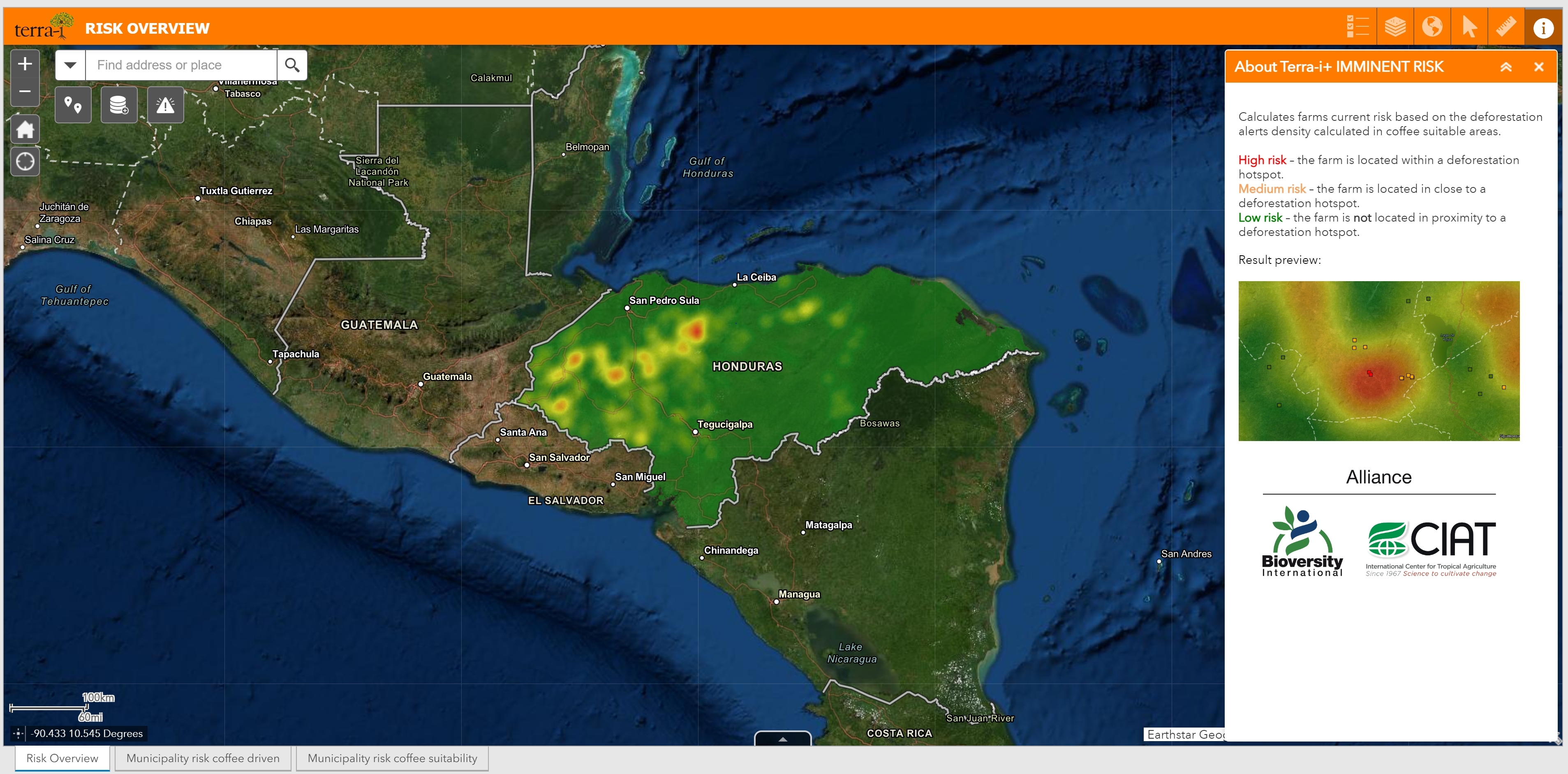
Developed sustainability indicators and interactive dashboards to track smallholder farmers’ practices
and environmental risks. This was a prototype of Terra-i plus.
These tools provide actionable insights for promoting sustainable and deforestation free agriculture in Honduras
with potential to scale up to multiple countries.
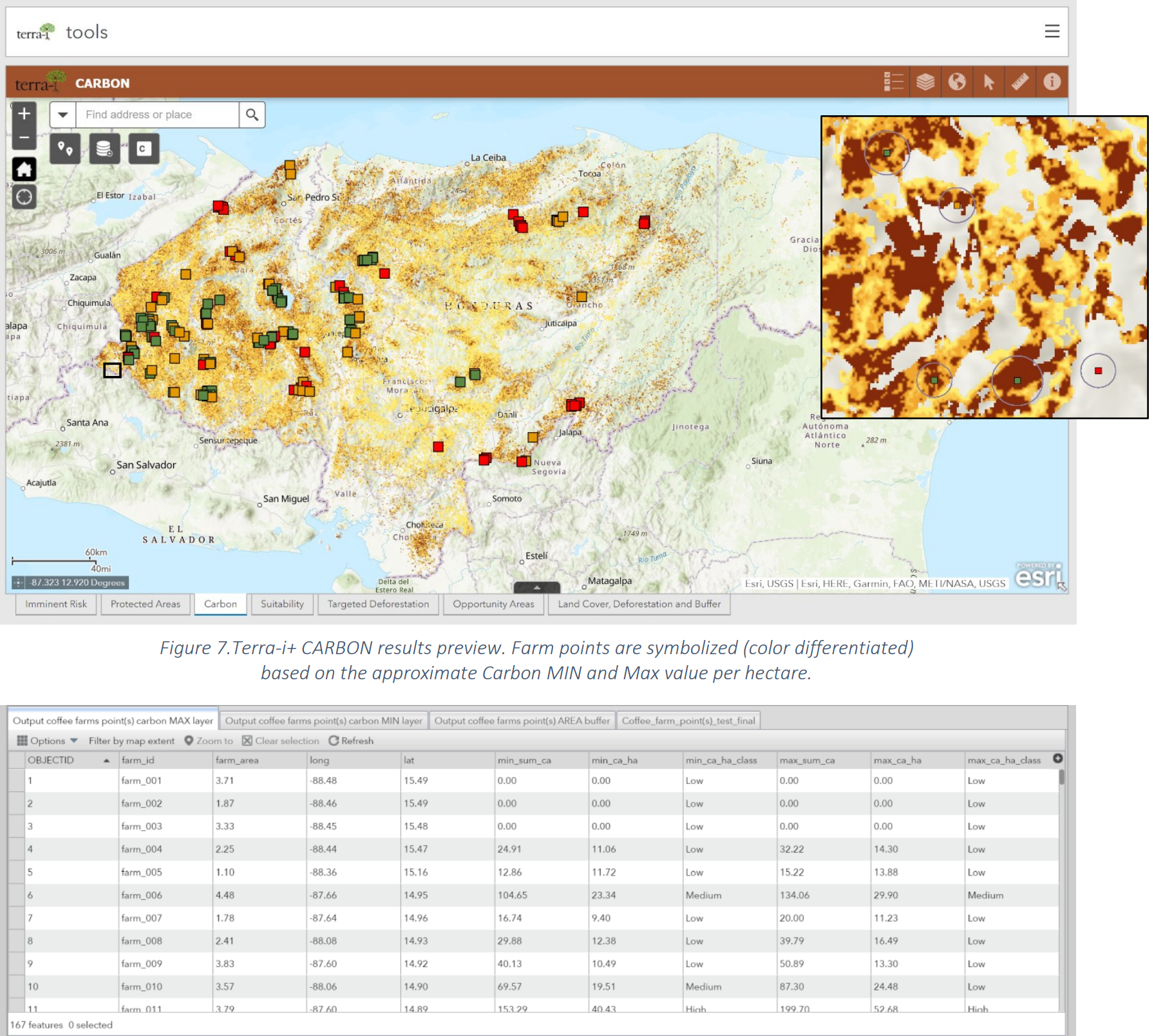
Conducted research on carbon estimation of cash crops using reference open datasets and medium resolution satellite imagery.
Assessed the feasibility of these dataset to differenciate different levels of shade in small holder coffee farms.
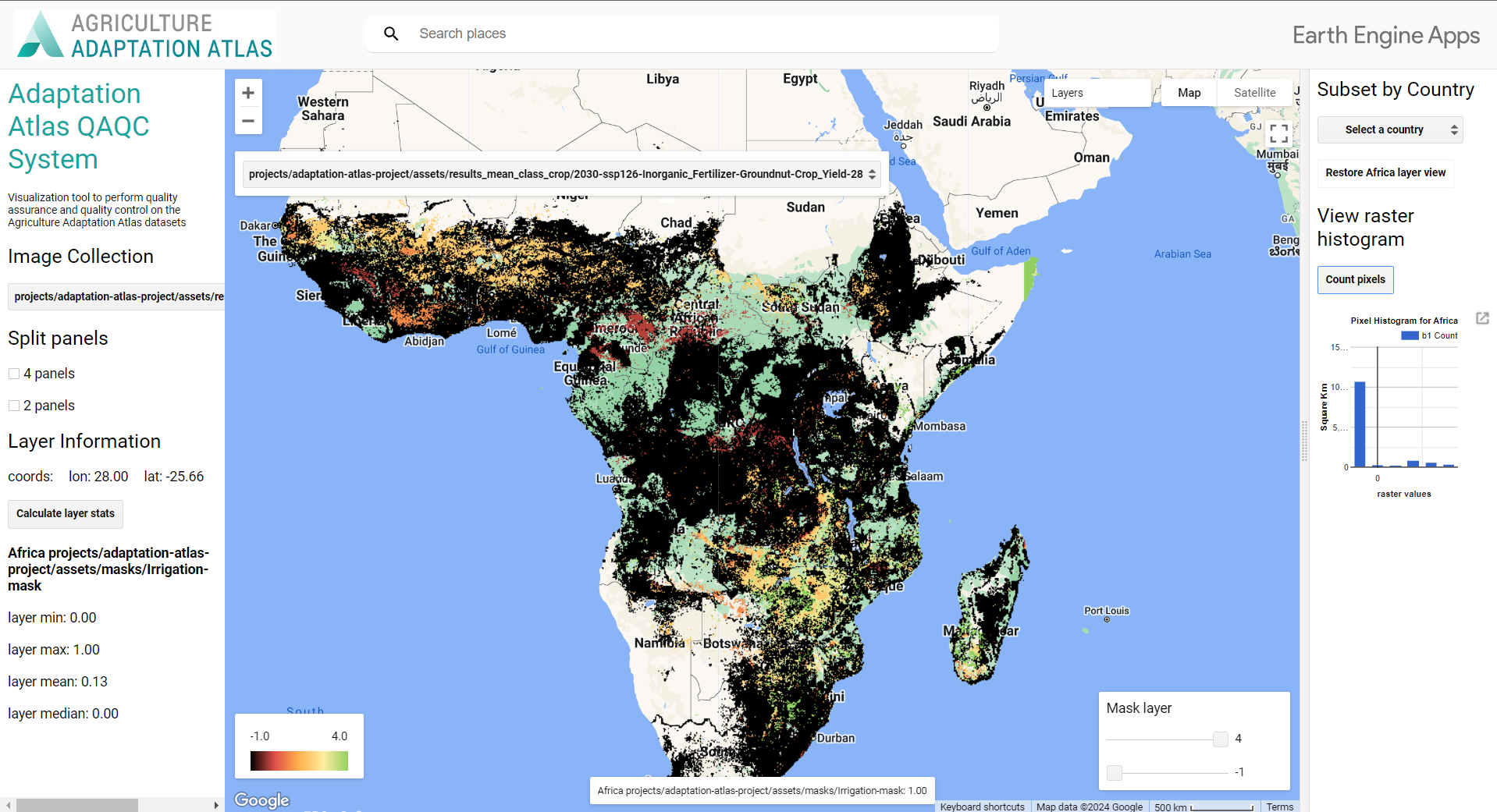
Led the development of a quality assurance/quality control (QA/QC) system for CIAT’s Agriculture Adaptation Atlas,
ensuring robust geospatial data validation and consistency across climate adaptation datasets.
Demos

This interactive Streamlit web app visualizes conflict event data from the ACLED (Armed Conflict Location & Event Data Project) API,
allowing users to select a country and time range to explore geolocated incidents such as battles, violence against civilians, and protests.
The app uses leafmap for dynamic mapping, pandas for data handling, and stores fetched results in to maintain interactivity across navigation.
Country masks are loaded as GeoJSON files to define spatial boundaries, enabling contextual analysis.
The app is designed for humanitarian, academic, or policy users needing timely insights into conflict dynamics.
The Agriculture Adaptation Atlas QAQC system is a Google Earth Engine (GEE)-based tool designed to perform quality assurance and quality control on geospatial datasets,
particularly those related to climate and environmental monitoring. It enables users to systematically identify and visualize data anomalies such as missing values,
outliers, and inconsistencies across spatial and temporal dimensions. With built-in functions for data import, visualization, and export, the tool supports interactive
review and facilitates reliable data curation for subsequent analyses or reporting. Its modular structure allows for easy adaptation to different datasets and QAQC
protocols within the GEE environment.
Contact
Elements
Text
This is bold and this is strong. This is italic and this is emphasized.
This is superscript text and this is subscript text.
This is underlined and this is code: for (;;) { ... }. Finally, this is a link.
Heading Level 2
Heading Level 3
Heading Level 4
Heading Level 5
Heading Level 6
Blockquote
block quote
Preformatted
i = 0;

while (!deck.isInOrder()) {
    print 'Iteration ' + i;
    deck.shuffle();
    i++;
}

print 'It took ' + i + ' iterations to sort the deck.';
Lists
Unordered
- Dolor pulvinar etiam.
- Sagittis adipiscing.
- Felis enim feugiat.
Alternate
- Dolor pulvinar etiam.
- Sagittis adipiscing.
- Felis enim feugiat.
Ordered
- Dolor pulvinar etiam.
- Etiam vel felis viverra.
- Felis enim feugiat.
- Dolor pulvinar etiam.
- Etiam vel felis lorem.
- Felis enim et feugiat.
Icons
Actions
Table
Default
| Name |
Description |
Price |
| Item One |
Ante turpis integer aliquet porttitor. |
29.99 |
| Item Two |
Vis ac commodo adipiscing arcu aliquet. |
19.99 |
| Item Three |
Morbi faucibus arcu accumsan lorem. |
29.99 |
| Item Four |
Vitae integer tempus condimentum. |
19.99 |
| Item Five |
Ante turpis integer aliquet porttitor. |
29.99 |
|
100.00 |
Alternate
| Name |
Description |
Price |
| Item One |
Ante turpis integer aliquet porttitor. |
29.99 |
| Item Two |
Vis ac commodo adipiscing arcu aliquet. |
19.99 |
| Item Three |
Morbi faucibus arcu accumsan lorem. |
29.99 |
| Item Four |
Vitae integer tempus condimentum. |
19.99 |
| Item Five |
Ante turpis integer aliquet porttitor. |
29.99 |
|
100.00 |